Notice: This page is still under development and currently being built. It is not yet intended for the public and will still change in content and appearance.
 For iPhone & Apple Watch
The companion app for your winter day: 20 winter sports with their own stats, pistes and lifts from 36 regions offline, a Help tab with emergency numbers, your saved hotel and a return reminder. Works with gloves through the Live Activity and Apple Watch.
Tap a group. Highlighted is what the app shows live and evaluates for it.
Every sport has its own live panels and stats: freestyle counts airtime, jumps and turns, ski touring shows the ascent rate in metres per hour, ice sailing counts tacks and gybes. Snowmobile has neither heart rate nor calories. Speed caps catch bad readings: if a value is too high, the app flags it as “too fast (car/lift?)” instead of saving it as a record.
Pistes, trails, lifts, huts, ski rental, ski school, mountain rescue and railway station from OpenStreetMap, offline for 36 regions. The app detects the region itself.
Piste and trail data: © OpenStreetMap contributors (ODbL), data as of 15 Sep 2026 · Source and download of the data. The data may be incomplete or outdated and says nothing about whether a piste or lift is open. Apple’s base map needs a connection.
Tap a segment in the elevation profile. This is how the day band is built, the one you see live, in the Live Activity and on the watch.
Barometer and GPS give accurate altitudes. GPS jumps are filtered out, standing still creates no phantom distance. Ski touring counts the ascent, sledding counts the run without a lift.
In the evening, “How was your day” shows every piste and every lift as a timeline, plus the “Lift sequence” map and the day report as a PDF.
Accommodation, emergency contacts, emergency numbers, ski-day plan and gear in one place. Works without GPS and opens with Siri: “I need help in Snow Compass”.
“What to say”: who, where, what happened, how many injured. The numbers are stored offline in the app, iOS asks before every call. The strip is fixed at the top of the Start tab, and there is an SOS widget. It does not replace an emergency call or an avalanche warning.
The side button before the start saves hotel, railway station, bus, meeting point, car park, airport, hospital or pharmacy, 19 categories. Share it as a QR code too. The compass takes a bearing to the saved place.
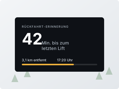
Last lift, bus or train, default 4:00 pm. The app shows the remaining time, sends a notification and reports “Missed” when it is too late.
“I am here” or a nearby hut as a message, also from the watch. There is no account and no friend network, just your message to your people.
The Help tab is always available. Without GPS it shows the saved data, contacts and the numbers of the last detected country. It does not replace an emergency call.
Weather from Apple Weather for the valley and summit stations, next hour, 24 hours and 10 days.
Fresh snow in the last 24 hours, visibility, wind and gusts for the lifts, UV index and the hint “sea of fog possible”.
Plus widgets for last ride, SOS, season and way back, right on your Home Screen.
“I need help in Snow Compass” opens the Help tab, “Start recording” begins the ride.
Without heart rate there are no zones and no load.
Sample values. Heart-rate zones and load are guidance, not a medical assessment.
Health and the watch are optional. Without both the app works fully, you just miss heart rate and zones.
Monthly goal: 20,000 m vertical14,000 of 20,000 done
Sample values.
Four views while riding, control without unlocking, values on your wrist.
No account, no server, no ads. iCloud is optional. If an entry changes on two devices, you decide: Local, iCloud, Both or Merge. Try it:
Ski day Hochalm
Tag: Ski
Ski day Hochalm, family
Tag: Holiday
No ads, no analytics, no developer server.
PDF for tours and day reports, GPX export and import (runs and lifts are detected again), full backup as .skt, import places.
In the background only during a recording. For the weather, the location goes to Apple Weather.
Only your private iCloud, health values stay on the device. The developer sees nothing.
Everything else is in the privacy policy.
What sets Snow Compass apart from a plain tracker is highlighted.
Emergency numbers for 119 countries offline, emergency contacts, saved accommodation. Works without GPS, opens with Siri.
Hotel, station or meeting point in 19 categories, share as a QR code. Return reminder with remaining time and notification.
Pistes, trails, lifts, huts and mountain rescue from 36 regions, without network and without subscription. Region detected automatically.
From skiing to dog sledding, each with its own live panels and stats such as airtime, ascent rate or tacks.
Run, lift, ascent and break automatically, pistes with name and difficulty, lifts by name. Correctable afterwards.
Timeline of your day live, in the Live Activity and on the watch. In the evening the “Lift sequence” map and the day report as a PDF.
Meeting point and lunch break with time and place. Send “I am here” or a nearby hut as a message, no server involved.
22 categories with photos, rental shop, period, price, return and overdue status. “Rent again” for next season.
Apple Weather for valley and summit, fresh snow, visibility, wind for lifts, UV, 10 days, “sea of fog possible”.
Round instrument with speed, elevation and heart rate. Compass with course and bearing to your saved place, such as the hotel.
Remote control and heart rate from the watch, five widgets, Live Activity with pause button without unlocking, two Controls.
Trends, records, zones, load 7/28 days, weekly and monthly goals, last season and the price per ski day.
A tracker counts runs. A companion also knows where your hotel is, when the last lift leaves and which number mountain rescue has.
€2.99 one-time for iPhone and Apple Watch. No sign-up, no ads, no tracking, no in-app purchases.
Comparison: According to vendor information (as of November 2026): Slopes, Ski Tracks and Strava work with subscriptions, most apps require an account.
Pistes, trails, lifts and huts from 36 regions are inside the app. Without network on the mountain you still see where you are.
Comparison: According to vendor information (as of November 2026): Slopes offers piste maps only with a subscription, Ski Tracks and Skiline have no piste data of their own.
Emergency numbers for 119 countries offline, emergency contacts, saved accommodation, return reminder. Available without GPS, opened with Siri.
Comparison: The compared apps' vendor information lists no emergency numbers or help view without a network.
Lift bar “START »” against accidental taps, pause button in the Live Activity without unlocking, remote control and live values on the Apple Watch.
Cross-country, ski touring, snowshoeing, ice skating, dog sledding and more, each with its own stats. And at the end of the season: what your season pass cost per ski day.
Comparison: According to vendor information (as of November 2026): Slopes, Ski Tracks and Skiline know skiing and snowboarding.
Snow Compass is the companion for your winter day. For summer and mountains there is the sister app Waymark with navigation to a saved destination. If you only want to count runs, heart rate and records, take the leaner fitness app OneTwo Ski.
Snow Compass next to three winter and three summer apps.
| Snow Compass | SlopesWinter | Ski TracksWinter | SkilineWinter | StravaSummer | KomootSummer | adidas RunningSummer | |
|---|---|---|---|---|---|---|---|
| Price and privacy | |||||||
| Price | €2.99 one-time | Subscription (Premium) | Subscription | free | Subscription (Premium) | Subscription + map purchases | Subscription (Premium) |
| Works without an account | ✓ | ✗ | ✓ | ✗ | ✗ | ✗ | ✗ |
| Data stays on the device, no vendor server | ✓ | ✗ | ✓ | ✗ | ✗ | ✗ | ✗ |
| No ads, no analytics or tracking SDKs | ✓ | ? | ? | ? | ? | ? | ? |
| Optional iCloud sync, you resolve conflicts | ✓ | own cloud service | ✗ | own cloud service | own cloud service | own cloud service | own cloud service |
| Sports and detection | |||||||
| Sports with their own metrics | 20 winter sports | Ski, snowboard | Ski, snowboard | Ski | 30+, generic | about 10, outdoor | Running, walking, cycling |
| Slopes, trails and lifts offline in the app (OpenStreetMap, 36 regions) | ✓ | ◐subscription only | ✗ | ✗ | – | – | – |
| Run, lift, climb and break detected automatically | ✓ | ✓ | ◐runs, no lifts | ◐turnstile only | – | – | – |
| Compass and speedometer view | ✓ | ✗ | ✗ | ✗ | ✗ | ✗ | ✗ |
| Safety and day planning | |||||||
| SOS emergency numbers for 119 countries, offline | ✓ | ✗ | ✗ | ✗ | ✗ | ✗ | ✗ |
| Emergency contacts and help view without network | ✓ | ✗ | ✗ | ✗ | ✗ | ✗ | ✗ |
| Save a place (hotel, station, meeting point) with way back | ✓ | ✗ | ✗ | ✗ | ✗ | ◐planning, account | ✗ |
| Return reminder (last train, bus, lift) | ✓ | ✗ | ✗ | ✗ | ✗ | ✗ | ✗ |
| Day plan | Ski day plan with meeting point and lunch break | ◐subscription | ✗ | ✗ | ◐routes, subscription | ✓ | ✗ |
| Share meeting point or position as a message, no server | ✓ | ◐friends, account needed | ✗ | ✗ | ◐Beacon, subscription | ✗ | ✗ |
| Keep track of gear and rental skis | ✓ | ✗ | ✗ | ✗ | ◐shoes, bike | ✗ | ◐shoes |
| Analysis and fitness | |||||||
| Logbook or tour journal with review, goals and records | ✓ | ◐subscription | ✓ | ✓ | ◐subscription | ✗ | ✓ |
| Track coloured by speed, altitude or heart rate | ✓ | ✓ | ✓ | ✗ | ◐ | ? | ? |
| Photos with position and heading on the map | ✓ | ◐no heading | ✗ | ✗ | ◐no heading | ◐no heading | ◐no heading |
| Apple Health: workout with route and calories | ✓ | ✓ | ✓ | ✗ | ✓ | ✓ | ✓ |
| PDF report, GPX export and import, full backup | ✓ | ◐ | ◐ | ✗ | ◐ | ◐ | ◐ |
| On the go | |||||||
| Weather with forecast in the app | ✓ | ? | ? | ? | ◐after the fact | ✓ | ? |
| Apple Watch | ✓ | ✓ | ✓ | ✗ | ✓ | ✓ | ✓ |
| Widgets, Live Activity and Control Centre | ✓ | ✓ | ? | ✗ | ◐ | ◐ | ? |
| Voice announcements | ✓ | ? | ✗ | ✗ | ✓ | ✓navigation | ✓ |
Legend: ✓ included · ◐ partly or subscription only · ✗ not listed in the vendor information (does not mean the feature is missing) · – not applicable to this app · ? no reliable information
As of November 2026. Sources: publicly available vendor information, App Store listings and vendor websites, retrieved in November 2026. What is not mentioned there is marked “✗”, even if the app may offer it. The selection of apps is not a rating or purchase recommendation. Please report errors or changes to support@onetwoapps.com; I will correct them promptly. Prices and features may change. Slopes, Ski Tracks, Skiline, Strava, Komoot and adidas Running are trademarks of their respective owners. OneTwoApps is not affiliated with these providers.
A simulated ski day in a made-up resort, entirely in your browser. Slopes, speed, elevation and heart rate are simulated, no location is requested. In the app the values come from GPS, barometer and Apple Watch. Switch between the four views, take a bearing to your saved place, take photos and set a return reminder.
Pick a sport and hold the lift bar “START »” until it locks on the right. In the demo time runs 30 times faster. For downhill activities the app tells lift, run and break apart by itself.
No photos yet. Tap the camera while recording.
Pick a sport and see which stats it gets and how the compass takes a bearing to your saved place.
Freely assigned tags and a selectable period separate evaluations or combine everything. Tap a day to see its timeline.
The first days are examples. Recordings you save from the simulator appear first and stay in this browser only.
Enter something and open the Help tab. Switch GPS off: the saved data stays available, in the app also the emergency numbers of the last detected country. Everything stays in this browser.
Tick off what you have done. Your progress stays in this browser only.
One-time · No subscription · No in-app purchases · No ads
The Apple Watch app, widgets and Live Activity are included. You pay once and use the app without ongoing or hidden costs. Requires iOS 18 or later.
Snow Compass for iPhone and Apple Watch. Slide the lift bar to the right and go.

Recording is only one part. Add the Help tab with emergency numbers, emergency contacts and saved accommodation, saving places, the return reminder, the ski-day plan with meeting point and lunch break, the gear list with rental skis and the weather for valley and summit. All without an account and without a subscription.
20: skiing, snowboarding, monoski, sit-ski, snowbike, telemark, freeride, indoor skiing, indoor snowboarding, cross-country skiing, snowshoeing, winter hiking, ski touring, fat bike, ice sailing, ice skating, snowkiting, dog sledding, snowmobile and sledding. Each gets its own live panels and stats.
No. The app also runs with the iPhone alone. With the watch you control the recording, see live values, day band, statistics and places, send the meeting point and get heart rate from a workout session. Recording always runs together with the iPhone; the watch alone does not record.
The piste data for 36 regions is inside the app: pistes, trails, lifts, huts, ski rental, ski school, mountain rescue and railway station are visible without a network, and the app detects the region itself. Apple’s base map needs a connection.
Fixed at the top of the Start tab is the red-bordered emergency strip with the numbers of the detected country: mountain rescue, air rescue, ambulance, fire brigade and police for 119 countries, stored offline in the app. There is also “What to say” and an SOS widget. iOS asks before every call. The app does not replace an emergency call.
Before you start, the side button saves a place in one of 19 categories, such as hotel, railway station, bus, meeting point, car park, airport, hospital or pharmacy. The compass takes a bearing to it, “Open in Apple Maps” guides you there, and you share it as a message or QR code. The app has no turn-by-turn navigation of its own.
A timeline of your day: runs, lifts hatched, ascents and breaks. You see it live, in the Live Activity and on the watch. In the evening “How was your day” shows every piste and every lift, plus the “Lift sequence” map and the day report as a PDF. Wrongly detected runs can be corrected afterwards.
From Apple Weather (WeatherKit) for the valley and summit stations: next hour, 24 hours and 10 days. The ski-day check sums up fresh snow in the last 24 hours, visibility, wind and gusts for the lifts and the UV index, and warns with “sea of fog possible”.
The Move ring counts the active energy of the whole day. Snow Compass always shows the calorie source: Health, heart rate or MET estimate. Lifts and breaks do not count.
No. Snow Compass is a sports and companion app. Heart-rate zones and load are guidance for your training, not a medical assessment.
Yes. Tours and day reports as PDF, every ride as GPX. You can import GPX tracks from other apps; runs and lifts are detected again. A full backup as an .skt file takes everything along, and places can be imported individually. iCloud is optional; on conflicts you choose between Local, iCloud, Both or Merge.
On iPhone with iOS 18 or later and on Apple Watch, with widgets, Live Activity and two Controls (“Start ride”, “Pause/Resume”). The app is available in English and German.
€2.99 one-time, no subscription, no in-app purchases, no account. All features are available immediately.
